
Scurt istoric
Coordinates: 46°34′15″N 23°46′45″E 46°34′15″N 23°46′45″E
Area
Total - 91.43 km²
Altitude - 315 m.d.m
Population (2011)
Total▼ 47744 inhabitants
Density 609 inh./km²
Previous census, 2002 55,887 inhabitants
Time zone EET (+2)
Summer time (DST) - EEST (+3)
Postal code - 401001-401189
Area
Total - 91.43 km²
Altitude - 315 m.d.m
Population (2011)
Total▼ 47744 inhabitants
Density 609 inh./km²
Previous census, 2002 55,887 inhabitants
Time zone EET (+2)
Summer time (DST) - EEST (+3)
Postal code - 401001-401189
Turda is one of the 6 cities of the Cluj county and the second largest, after the county seat, in terms of population (55,804 inhabitants, cf. Local Population Sheet prepared by INSSE), representing 8.31% of the total population of the county and 14.57% of its urban population.
Turda is located at the intersection of European roads E68, E81 and E60, on the Arieș Valley, in an attractive area both from a tourist and an socio-economic point of view, near three county seats (Cluj-Napoca - 30km towards the North, Târgu-Mureș - 70km towards the East, Alba-Iulia - 70km towards the South). The total area of the municipality is 91.6 km².
With its Gothic or Renaissance style architecture, which we can find in the old part of Turda, it falls into the category of centers with urban tradition in Transylvania and is, at the same time, a source of delight for any tourist who wants to visit this area, known under the name of Potaissa during the D.D.H. period as a Dacian citadel.
Turda is one of the old and important settlements in the history of Romania. The city developed in the valley of the Arieș River. Due to archaeological discoveries, we learn that the area of the current city and its surroundings has been inhabited since prehistory. There are numerous archaeological remains (stone tools, fragments of ceramic vessels, skulls, etc.) discovered in the over 100 caves in Cheile Turzii and in the villages of Bădeni, Moldovenești, and Mihai Viteazu.
As a result of preventive archaeological research conducted on section IIB2 of the Transylvania Highway, near the village of Săndulețti, on the Turenilor Cliff plateau, 210 archaeological complexes (deepened dwellings, tombs, ritual deposit pits, provision pits, pole pits) belonging to successive prehistoric villages have been revealed. The first discoveries are those of a small settlement belonging to the developed Neolithic period (4900-4700 BC). A more consistent community occupies this high plateau in the final Eneolithic period (Coțofeni culture, 3000-2500 BC). In the Bronze Age, the promontory was defended from the west with a trench, rampart, and palisade, and the plateau became a fortified settlement, probably in the middle Bronze Age (Wietenberg culture, 1700-1400 BC). This is the period of maximum prosperity of the settlement, not a seasonal settlement, but a stable and important center in the Transylvania Plateau. However, there are also discoveries belonging to the early Bronze Age. Smaller dwelling continues even in the late Bronze Age (1400-1200 BC). On the same plateau, especially in the upper levels, Roman ceramics were discovered. The actual Roman dwelling is probably located to the west, on the higher area of the plateau, and is in connection with the Roman quarry at Săndulești and the aqueduct that captured the Copăcenilor spring and supplied water to the city of Potaissa and the Roman fort.
Despite the name Potaissa being a toponym of Dacian origin, the archaeological discoveries on the territory of the city are quite modest, making it difficult to locate the exact settlement of the Dacians. A Dacian cup comes from the Şuia Hill, and other ceramic fragments from the former Téglás collection, as well as tools, arrowheads, daggers, etc., have been discovered in different points on the Dealul Zânelor, the Sândul Valley, and the Pordoi Valley. Potaissa would have remained at the pre-urban stage of evolution, a market, if it were not for the politically-military events of overwhelming importance in Dacia's history at the beginning of the 2nd century AD.
After the conquest of Dacia by the Romans, after the two wars (101-102 and 105-106 AD), the small town on the bank of the Arieș river kept its Dacian name. Written sources attest to this name in different corrupted variants: "Patrouissa" in Ptolemy, Patabissa in the work of the Anonymous Geographer of Ravenna, but the name must have been "Patavissa" as on the Tabula Peutingeriana or in the passage of the jurist Ulpianus. The first epigraphic mention of the locality dates from the year 108 AD on the milliarium of Aiton, in the context of building the imperial road section between Potaissa and Napoca, where the simplified form Potaissa appears. A replica of this "kilometer stone" can be admired in Turda's 1 December Square or in the village of Aiton. Then, on a medieval map (Tabula Peutingeriana), the distance between Potaissa and Napoca is recorded at 35,484 km.
The town experienced significant growth only after the installation of the 5th Macedonian Legion garrison near it. The village became a municipium during the reign of Emperor Septimius Severus, and if we believe Ulpianus, it reached the highest municipal rank, that of a colony, during the same emperor.
The ruins of the old city are spread over the hills and valleys on the left bank of the Aries, partially overlapping the medieval and modern city of Turda. The plan of the old city, with residential areas and cemeteries, is more difficult to guess and also because at least two Roman communities with different statuses coexisted: the village that became a municipium (and perhaps a colony) and the civilian community that was born near the legionary fort, the canabae, consisting of Roman citizens and veterans.
In the vicinity of the legionary fort, the city prospered and became an important center in the north of the province of Dacia. Development was also favored by the city's location on the imperial road and close to the navigable Mures corridor, as well as the rich natural resources in the area, such as gold from the Apuseni Mountains and salt.
To maintain the borders of Dacia and the Roman Empire during the Marcomannic Wars, around 170 AD, the emperor Marcus Aurelius transferred the 5th Macedonian Legion from Dobrogea to Potaissa. The legion built a fort in an excellent strategic position: on a plateau (the "City Hill"), protected from floods and streams, but close enough to a water source. The plateau had a dominant position over the ancient city and the surrounding territories, with good visibility from the fort. It is the largest legion fort in Dacia, with a long operation (around 170-270 AD). Over 5000 soldiers carried out their daily activities here. The fort, one of about 70 legion forts in the Roman Empire, is the most important historical and archaeological monument of Potaissa. The rectangular fortification (573X408 m) covers an area of 23.37 hectares and was built according to all the rules of the time. The perimeter wall was 5 m high and in front of it was a 12 m wide defensive moat. The fort had four gates connected by internal roads and flanking towers. There were also bastions at the corners of the fort. You can still see the gate on the west side (the decuman gate) and the bastion in the northwest corner of the fort. The entire area was wisely designed according to Roman military architecture. In the center was the headquarters building (principia), which has been studied and restored. Next to it, to the south, was the barracks of the 1st cohort, a unit of 1000 soldiers. Another large archaeologically researched complex consisted of the fort's baths (thermae) and the exercise hall (palestra). The fort also had barracks for the nine cohorts of 500 soldiers each, officers' quarters, grain depots, workshops, and a military hospital.
The construction of large buildings within the fortress or those that, although outside the fortress, were functionally connected to it, was staggered over a longer period of time. This is evidenced by the several inscriptions that mention the inauguration or rebuilding of buildings at different dates.
Archaeological research conducted annually in the fortress (from 1971 to present) has brought to light, besides the aforementioned constructions, a rich archaeological material exposed in the Turda museum: common use objects (tools, ceramics), specific weapons and military equipment, coins, decorations, sculptures, and stone inscriptions. The consolidation and restoration works bring into the tourist circuit some of the researched vestiges.
The Fifth Macedonian Legion will leave Potaissa during the time of Gallienus, or under his successor, Aurelian. The former flourishing city declines after the year 271 AD. Potaissa is also abandoned by part of the civilian population. Gradually, in the following two centuries, the city becomes rural. The inhabited areas shrink, the craft production remains modest. Some objects dated in the 4th-5th centuries AD (ceramic vessels, opiums, decorative objects) discovered in Potaissa prove that the relationships with the Late Roman Empire have not disappeared completely. The monetary circulation, limited, continued in the 4th-5th centuries AD, the last Roman coins circulating in Potaissa in the 6th century AD. The main wealth of the locality remains salt in this era.
After the withdrawal of the Romans and until the 6th-7th centuries AD, the first migratory populations (vandals, various branches of the Goths, Huns, Alans, Avars) passed or temporarily settled on the territory of Romania.
The abandoned castle by the military was not inhabited by the citizens of Potaissa and gradually began to deteriorate. Only in the 5th century AD, groups of migrants settled temporarily in the castle: first the Alans, then the Eastern Germans (Gepids). It is possible that these maintained to some extent the old castle buildings, lived in them, and transformed the imposing ones, such as the baths, into "palaces" for their aristocracy. In 1996, during systematic archaeological research in the castle's baths, a rich tomb of a "princess" was discovered, representing the most spectacular discovery. The woman was of small stature (about 150 m), lived about 35-45 years and had several births. The decorations (gold and almandine earrings, two large silver policrome fibulas and a belt buckle made of silver, gold and almandine; amber beads), as well as toilet objects (a bone comb and a round metal mirror) and even small fragments of linen clothing were preserved. Only the silver buckles of the shoes were preserved. The deceased's skeleton and rich inventory is displayed in the main exhibition of the Turda History Museum.
The medieval history of Turda is inextricably linked to the exploitation of salt. The name Turda first appears in documents in 1075, mentioned in connection with this activity. It refers to an act issued by King Geza I of Hungary (1074-1077). In this context, the Hungarian monarch made several gifts to the Benedictine monks (from today's Slovakia).
From the 11th to the 12th centuries, in the Turda area, we have archaeological finds of great importance, both for the history of the locality and for that of Transylvania (monetary treasures, decorations, ceramic vessels, weapons and military equipment). Most of the pieces discovered during these researches are found in the history museums collections of Cluj-Napoca and Turda.
Some of these discoveries were made near the Moldovenești fortress, where many historians presume the "Turda fortress" mentioned in the document issued in 1075 would be located.
The city of Moldovenești was abandoned, most likely being destroyed by the great Tatar invasion of 1241, during which Turda also suffered greatly. After the Tatars retreated, the castle was not rebuilt; instead, the kings of Hungary rebuilt the city of Turda, which provided the kingdom with salt supplies and revenues.
The salt mine in Turda is documented in 1271 in a document issued in the Buda castle, by which King Stephen V of Hungary granted the Turda salt mine, which was removed from any royal or princely authority, to the Transylvanian Church. Institutionally, salt exploitation was regulated by the salt chambers, the most important one in Transylvania being the one in Turda. This institution was led by a count, who, due to this function, became an important figure in Transylvania. The House of Salt Chamber still exists today, its location being in the building of the current history museum in Turda. It is the only former house of the chamber that is still preserved today.
Of the 51 counts of the Turda Salt Chamber House identified, the most representative was Miklós Pogány, who lived in the 15th century. He was one of the important collaborators of Iancu de Hunedoara, together with whom he participated in the anti-Ottoman campaigns of 1442, respectively in the battles at the Iron Gate of Transylvania and the battle on the Ialomița river.
Turda was the seat of the county of the same name, attested in 1279 in an act of King Ladislaus IV Cuman, by which he reinforced the ban Micud with several estates in the counties of Dăbâca and Turda. During the Middle Ages, the Turda county was one of the 7 counties under the authority of the Voivode of Transylvania. The city maintained its regional center character, both in the era of the autonomous Principality (16th-17th centuries), and after Transylvania became part of the Habsburg Empire.
Most of the general assemblies of Transylvania during the principality were held in Turda. The first documented assembly was on June 8, 1288 during the rule of Prince Roland Borșa.
The assembly was one of the fundamental institutions of the Transylvanian principality, representing the public gathering of nobles with legal, legislative, fiscal, and political competencies. They would meet at the call of the prince or the vice-prince on his behalf. Their usual place was near the city of Turda (Cristiș).
In the 14th-17th centuries, Turda experienced significant growth as part of the overall progress of the Transylvanian economy, particularly in mining. The economic development led to the construction of more important buildings in the city. Around 1400, the current Reformed church was built in the center of Turda. In the second half of the 15th century, the Roman Catholic church was also built on the northern side of the central square. Turda developed both economically and urbanistically. During this period, the city was enriched with two new central area churches and then the fortressed church in Turda Noua. Also in this period, the important construction of the city, the Chamber House, is documented.
Once the construction works on the Roman Catholic church were completed at the beginning of the 16th century, the main square of the city was closed on its northern side. The city's street plan still retains its medieval structure with a main street having a central thickening for the square. The square space was primarily intended for economic activities. Periodic fairs were held here, selling both local and foreign products from merchants. Gradually, the main square acquires administrative, political, and social functions by hosting various important events in the city's life, including diets and various performances staged by traveling theater troops that roamed the cities of Transylvania.
Information about the city square and the homes located here is scarce, and the first information is only available in the mid-15th century. Simple, mostly one-story houses were surrounded by gardens. The city was crossed from one end to the other by three parallel streets and had three squares. The hay square (today's December 1, 1918 square), in the middle of which was the 18th-century Lutheran church (which was demolished in the communist era), and the Prefecture building (today's City Hall), built in the second half of the 19th century. The most imposing buildings were found in the city's central square. Some of these still exist today. Representative of the city's history are: Becski House, Fodor House (today's Billa store), Harmath House, Kimpel House (Republicii, 47- baroque houses), Prefect House (today's BCR headquarters), Tăbăcarilor House (Republicii, 10), Teglas House (Republicii, 27), Toth House (near the City Hall), Tutschek House, Rațiu Houses, Prefecture Building (today's City Hall), Mihai Viteazul College, Wesselenyi House, Elisabeta Hotel (entry to the food market), Finance Palace (Republicii, 15), Miko Palace (Medieval Inn, Republicii, 8), Voivodal Palace (Hașdeu, 2), Catholic School (Republicii, 1), Unitarian School (Dacia street), Reformed School (Republicii 16), Municipal Theater, Old City Hall (former Courthouse, Republicii 5), Mendel Villa (former Army House).
Starting from the 16th century, during the Principality of Transylvania, the Diet of Transylvania (127 meetings) was often held in Turda. This institution was a deliberative political assembly with powers in the fields of legislation, justice, and administration of Transylvania, composed of representatives of the privileged orders and estates (Saxons, Szeklers and Hungarians), who together with the prince exercised state leadership. At the diets of 1542 (Târgu-Mureș and Turda), the concrete foundations of the Principality of Transylvania under Ottoman suzerainty were laid.
Before the religious reform in Turda, there were three confessions: Catholic, Orthodox and Mosaic. After the Reformation and especially after the Edict of Tolerance of 1568 held in Turda, which proclaimed religious freedom for the first time in Europe, Turda, along with Transylvania, became a confessional mosaic, to which the above-mentioned confessions were added: Reformists, Evangelical-Lutherans and Unitarians.
Throughout history, a series of political events have taken place in Turda that have marked the history of these places. In 1438, the Union of the Three Nations was signed in Turda, which prevented Romanians from participating in the country's political life. On the background of rebellions at first and then by peasant rebellions, which spread throughout Transylvania - the rebels from Bobâlna conquered Cluj, Turda, and Aiud. After suppressing the rebellion, nine leaders of the rebels were hung in Turda.
Turda suffered destruction during the wars fought by Michael the Brave (1593-1601) against the rebel Hungarian nobility, as well as in the troubled times that followed the assassination of the ruler, when the army of Emperor Rudolph led by imperial general George Basta engaged in serious excesses, burning and devastating the city. During these politically unstable years and dotted with numerous military conflicts, the medieval civil and ecclesiastical buildings in Turda Veche and Turda Nouă suffered significant damage. Among the fires, the one in 1658 seems to have seriously affected the city, and the incursions of the Tatars during those years destroyed several cities in Transylvania.
In the first half of the seventeenth century, Turda recovered from the aforementioned devastations and the plagues of bubonic plague and cholera that followed, being repopulated with soldiers released from the army in 1619 and with refugees from Caransebeş, Lugoj and Oradea in 1665. To redress the demographic situation, they were stimulated by the numerous privileges granted by the Princes of Transylvania, starting with Gabriel Bethlen, George Rákóczi I, George Rákóczi II and Michael Apafi (1662-1691), so that Turda became a noble city in 1662, with all the rights and privileges due.
At the beginning of the 18th century, a major event that resulted in significant destruction took place during the war between the Cossacks and the wolves, when Turda was burned, pillaged and raided repeatedly under the rule of the Prince of Transylvania Francisc Rákóczi II (1704-1711). The damage resulted in the loss of its role in salt commerce.
Crafts guilds played a very important role in Turda's economic development during the medieval and modern periods. The first records of the existence of specialized craftsmen in Turda date back to the 14th century.
Throughout history, the Princes of Transylvania have granted and reconfirmed numerous privileges to Turda and its inhabitants. Such decisions encourage the existing guilds in the town, especially under the rule of Princes Gabriel Bethlen, Gheorghe Rákóczi I, Gheorghe Rákóczi II, and Mihail Apafi. The activities of the guilds were encouraged, including those of coopers, tailors, furriers, shoemakers, potters, and butchers. The guilds operated in Turda until 1872, when they were transformed into craft associations.
At the end of the 19th century, Turda experienced significant economic and industrial development. The diversification of economic activities made Turda a significant industrial center. The oldest factories established in Turda were the beer factory, the cellulose factory, the soda factory, the cement factory, and the gypsum factory.
Market economy, production and circulation of goods have also had a significant monetary circulation in Turda. The scope and dimensions of this were conditioned by the development of production and the circulation of goods.
Among the noteworthy events in the modern history of Turda would be the one that took place in 1810, when Vasile Moga was elected as Orthodox bishop at the Church Between Romanians. In 1847, the well-known Pașoptist revolutionary Andrei Șaguna was ordained as Orthodox bishop at the same church.
In modern times, the Romanian noble family Raţiu de Nagylak has made a major and significant contribution to the development of the city of Turda. The first important member of the family was the Greek-Catholic priest Baziliu Rațiu, who built the church of the Rățești, consecrated in 1839 and donated a large part of his wealth to the construction of the first Romanian school in Turda (1873-1874).
The greatest personality of the family who worked in Turda was Dr. Ioan Rațiu. A remarkable politician, a highly valued and prestigious lawyer, Dr. Ioan Rațiu was a fighter for the rights of Romanians in Transylvania. For a long time he was also the president of the National Party of Romanians in Transylvania, and was the initiator and coordinator of the memorandist movement of 1892. Dr. Ioan Rațiu left as a testament to posterity his famous words: "The existence of a people is not discussed, it is affirmed." A exhibition dedicated to the Rațiu family and the history of this family can be seen at the Turda History Museum.
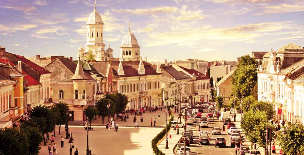
The urban landscape of the city was enriched in the interwar period, thanks to the efforts of the Orthodox protopop Iovian Mureșan, who built the impressive cathedral in the center of the city (1926-1935). From an industrial city that had become so since the pre-war period, today Turda has a tourist and cultural preponderance. Among the most important natural tourist attractions in the surrounding area are:
-Turda Gorges, an impressive natural monument, formed by the mountain being split by the Hașdate stream;
-Borzești Gorges, which presents two wild sectors (upper and lower waterfalls) that flow into the Arieș river;
-Ciucaș Waterfall, which presents many slope ruptures, with rapids and waterfalls.
-Papara's Huda Cave, housing the largest colony of bats in Europe, crossed by three streams (Ponor, Poieni, and Seacă).